

Long before there were digital Google Maps, Rand McNally road atlases and Michelin fold out maps there was the Forma Urbis Romae, or Marble Plan, an extraordinary plan of every street and building existing in early third-century Rome. Incised on one hundred fifty marble slabs, the plan was sixty feet wide and forty-three feet high and hung on a wall of the Temple of Peace, now the east façade of the Basilica of Saints Cosmas and Damian on the Via dei Fori Imperiali. As with most of ancient Rome, the marble slabs came tumbling down and now only about fifteen percent of the original map survives in a jigsaw collection of over eleven hundred pieces. While we usually see ancient pieces in books and exhibition display stands, now, there is a rare opportunity to see an important and newly discovered piece of the map on display through March 17 at the Museo dell’Ara Pacis.
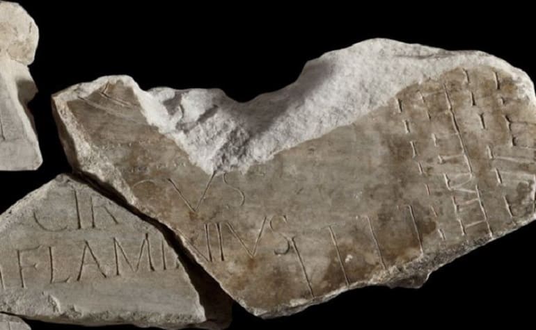
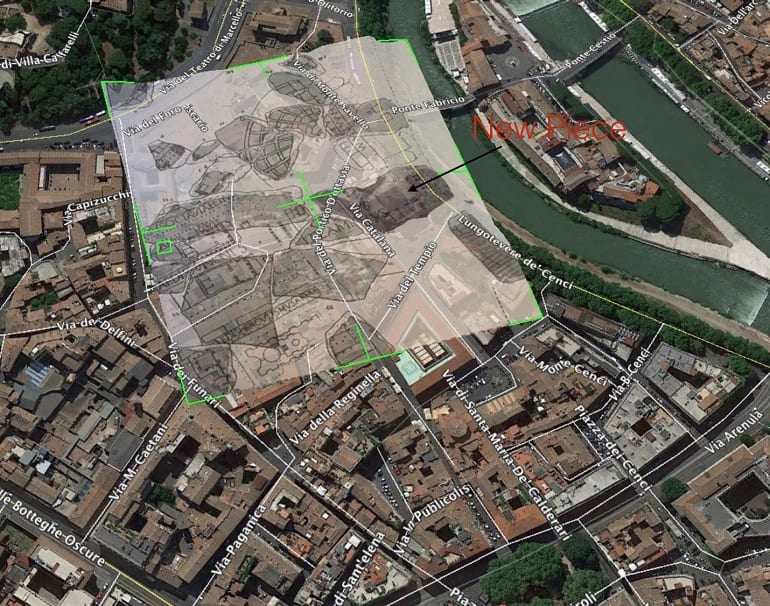
Its find announced last month, the fragment was discovered during excavations in the Palazzo Maffei Marescotti on the Via della Pigna in the area behind the Pantheon. How the piece ended up under the palazzo and so far from its original mooring at the Temple of Peace is unknown, but this was the part of Medieval Rome where much ancient marble was brought to be burned in kilns and turned into lime for construction. Having been saved from the ovens, the chipped marble fills in an important missing piece of the map in the area of the Via del Portico d’Ottavia and for many centuries Rome’s Ghetto. In ancient times, this was the area of the city known as the Circus Flaminius, and the recently discovered piece fits with a long known fragment to complete the map label of this space. Buildings that may have related to the Theater of Marcellus next door are also shown on the fragment. More likely a public gathering space and market area rather than a “circus” for games such as the Circus Maximus, the Circus Flaminius was flanked by beautiful porticos and temples and triumphal parades for Rome’s greatest generals such as Pompey likely formed up in this area before wending their way through the city gates to the applause and shouts of the crowds.
Most of the surviving pieces of the third-century map were found in the sixteenth century, but over the past five hundred years a few more fragments have turned up. The remaining parts of the Marble Plan have provided a hugely important tool for researchers on Roman topography as well as a source of inspiration for artists such as Piranesi who often included pieces of the Forma Urbis Romae in his prints. At the beginning of the twentieth century some of the larger pieces were on display in the Capitoline Museum before being relegated to storage. Now, for the first time in a long while the public can see a part of the Marble Plan. The new find will add critical information to our snapshot of Rome at the height of the empire and its public display, albeit short, provides a rare opportunity to see a broken but important “piece” of it and should not be missed.
Paul Jacobs is the co-author of Campus Martius – The Field of Mars in the Life of Ancient Rome published last year by Cambridge University Press and the recent eBook walking tour entitled A Walk Through The Field of Mars – Rome’s Ancient Campus Martius A Piedi. His blog on things to do in the area is found at CampusMartiusRome.com.

